
Data Centre Survey
Condition Overview of Building and Adjoining Land
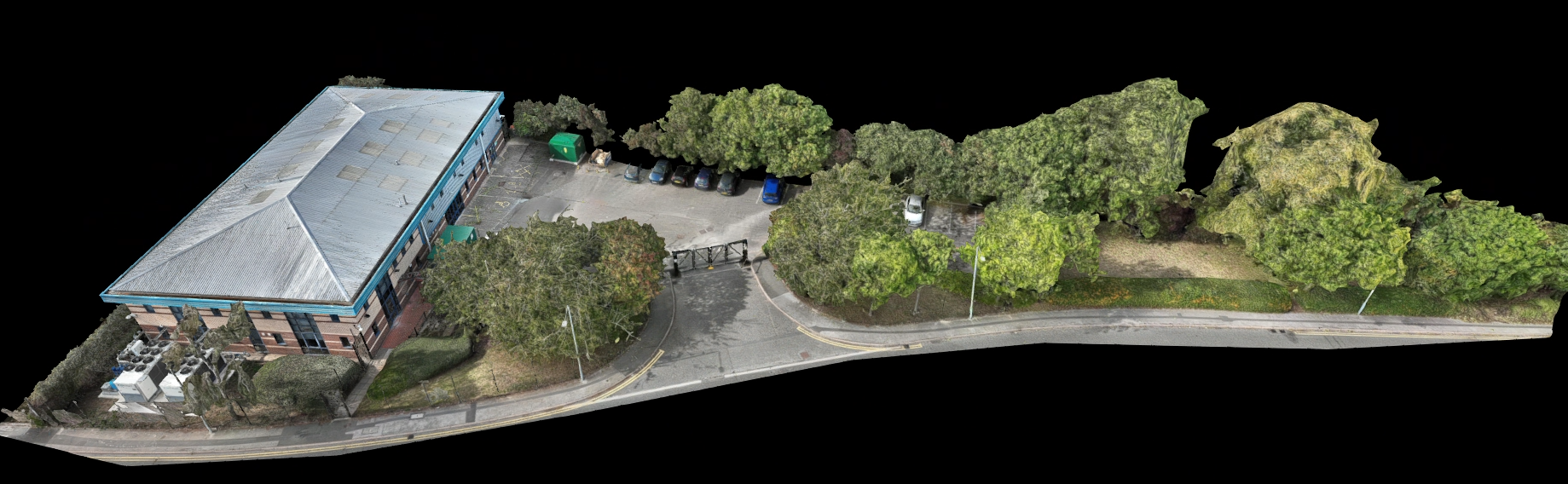
Overview
Client had moved into new leased premises and required an overall condition report of the building, car park and access road.
Sector - Data Centre
Output - 3D model, High Density Point Cloud, 2D Orthomosaic, Aerial Photography
Location - Nottinghamshire
Delivery - Sept 2025
Drone Data Capture Method
1. Office Preparation
Checked airspace restrictions and confirm required authorisations and permissions.
Completed pre-flight assessments in line with CAA requirements.
Planned the mission route, including flight altitude, speed, and area coverage using DJI Pilot 2.
2. Flight Route Planning:
Used the DJI RC Plus 2 controller to visualise and refine the route on site ensuring all hazards had been accounted for whilst maintaining the needed parameters of the data capture.
3. Oblique Data Capture:
The first flight was to capture oblique images around the building from multiple angles.
The location of numerous trees around the edge of the building meant that the altitude and GSD were set to safely avoid these during the capture.
4. Ortho Data Capture:
Defined the survey area using the DJI RC Plus 2 controller to focus on the roof of the building.
The drone flew the automatically generated optimal flight plan after the speed, altitude and GSD were set.
5. Additional Manual Data Capture:
In order to accurately capture the facades of the building, the drone was flown manually in 1 second auto photograph mode at a matched GSD from the building.
The drone was expertly flown by our pilots in a lawnmower route, ensuring coverage of the facades and avoiding the trees around the edge of the building.
Captured high-resolution images with the Matrice 4E’s 20MP mechanical shutter sensor for low distortion and clarity.
6. Survey Quality Check:
After the flight, reviewed the survey quality report metrics for photo count, overlap, distortion correction, and RTK positioning data.
Ensured data completeness and accuracy before processing.
7. Data Processing:
Imported the images into DJI Terra software.
Processed the imagery to generate a detailed 3D model (point cloud, mesh, textured model) and an accurate 2D orthomosaic map.
8. Reporting and Delivery:
Delivered the point cloud, 3D mesh & orthomosaic map to the client as well as uploading all data to Nira and providing the client with this online resource to visualise and review.
Accurate and Detailed Visual Record
Capture the exact state of the property at lease start, including precise measurements and visual details, creating a comprehensive baseline for future comparison.
Benefits

Dispute Prevention and Evidence
Provides indisputable proof of the building’s condition at move-in, helping to avoid or quickly resolve disputes about damages or alterations when the lease ends.

Remote Access and Collaboration
Stakeholders can assess the space anytime from anywhere, supporting remote inspections, maintenance planning, and tenant communication without physical visits.

Efficient Maintenance and Management
Facility managers use the 3D model for precise planning of repairs, renovations, or upgrades, reducing errors and rework by extracting accurate measurements directly from the model.
Insurance and Compliance Documentation
The 3D model serves as robust documentation for insurance claims and regulatory compliance by providing verifiable, dated records of the property’s condition.

Time and Cost Savings
Reduces the need for repeated site visits and on-site measurements, saving time and costs while improving overall management efficiency.