
Drone Property Inspections and Aerial Surveys Across the UK
Safe. Efficient. Cost-Effective. High-Quality Results
At Drone Discovery Ltd, we provide cutting-edge drone inspection services and aerial surveys throughout the UK. Using high-resolution drone photography and videography, we offer a modern, cost-effective alternative to traditional building inspections — all without the need for scaffolding, cherry pickers, or rope access.
Our drone aerial surveys are suitable for all types of properties. From small residential homes to large commercial complexes and historic buildings, we have experience across a wide range of sites and structures. Our unmanned aerial vehicle (UAV) systems capture detailed aerial images and videos of hard-to-reach areas, reducing risk and saving time.
Why Choose Drone Inspections?
Traditional surveys often involve expensive equipment, safety risks, and logistical challenges. Our drone services remove those obstacles by offering fast, affordable, and reliable access to even the most awkward or elevated areas. A drone inspection can typically be completed in a matter of hours — not days — giving you clear visual data for assessment, planning, or reporting.
Benefits of Drone Inspections:
No need for scaffolding or mechanical lifts
Reduced health and safety risks
High-resolution 4K drone video and 20MP aerial photography
Same-day or next-day turnaround on results
Minimal disruption to the property or occupants
Access to difficult areas including valleys, steep slopes, and tight spaces
Drone Inspections for a Range of Industries
Whether it’s for a one-off inspection or part of a larger project, our drone imagery & data enhances planning, reporting, and preventative maintenance. We also offer discounted rates for contract clients and multi-site portfolios. Whether you’re a homeowner, property manager, surveyor, or construction professional, we tailor each project to your specific requirements.
Construction & Infrastructure
Roof inspections
Façade and cladding inspections
Bridge and overpass inspections
Tower crane and scaffolding checks
Progress monitoring on construction sites
Transport & Rail
Railway track and overhead line inspections
Tunnel and embankment surveys
Port and dock structure assessments
Utilities & Energy
Power line and transmission tower inspections
Wind turbine blade inspections
Solar panel array assessments
Substation and transformer inspections
Agriculture & Environment
Tree health and forestry inspections
Flood risk assessments and drainage checks
Wildlife monitoring and habitat analysis
Oil, Gas & Industrial
Flare stack inspections
Pipeline integrity checks
Refinery and tank inspections
Confined space inspections using specialised indoor drones
Insurance & Property
Storm or fire damage assessment
Pre- and post-claim inspections
High-rise property and chimney inspections
Residential, Commercial, and Heritage Surveys
Our drone aerial surveys are suitable for all types of properties. From small residential homes to large commercial complexes and historic buildings, we have experience across a wide range of sites and structures.
We regularly inspect:
Detached homes, terraced houses, and apartment blocks
Office buildings, warehouses, shopping centres, and solar farms
Listed buildings, towers, and churches
Every drone flight is customised to the layout, surroundings, and access requirements — and carried out in full compliance with CAA regulations. Our risk assessments and safety checks are completed in advance, ensuring a smooth and professional experience from start to finish.
Certified, Insured, and Trusted

Safety and professionalism are at the core of everything we do. We can conduct inspections and aerial surveys independently or with you on-site. Drone Discovery Ltd is:
Fully CAA-approved and compliant with airspace regulations
Backed by public liability insurance (minimum £1M coverage)
Experienced in operating in urban, rural, and sensitive environments
Advanced Drone Technology for Accurate Data

Our drones are agile and highly stable, capable of flying close to structures and navigating confined spaces safely. We use the latest quadcopter drone technology equipped with:
4K video cameras for crystal-clear motion drone footage
20-megapixel sensors for detailed still imagery
Precision GPS and RTK systems for accurate surveying and mapping
Automated missions to capture the same viewpoint and flight path for consistent comparisons
Fast Turnaround and Responsive Service

Our drone services are ideal for urgent assessments, post-storm damage, property sales, lease evaluations, or insurance claims. We understand that time is often critical. That’s why we offer:
Rapid on-site setup (15–20 minutes)
Inspections completed in under 2 hours (typical residential property)
Results delivered within 24 hours
Same-day turnaround available on request
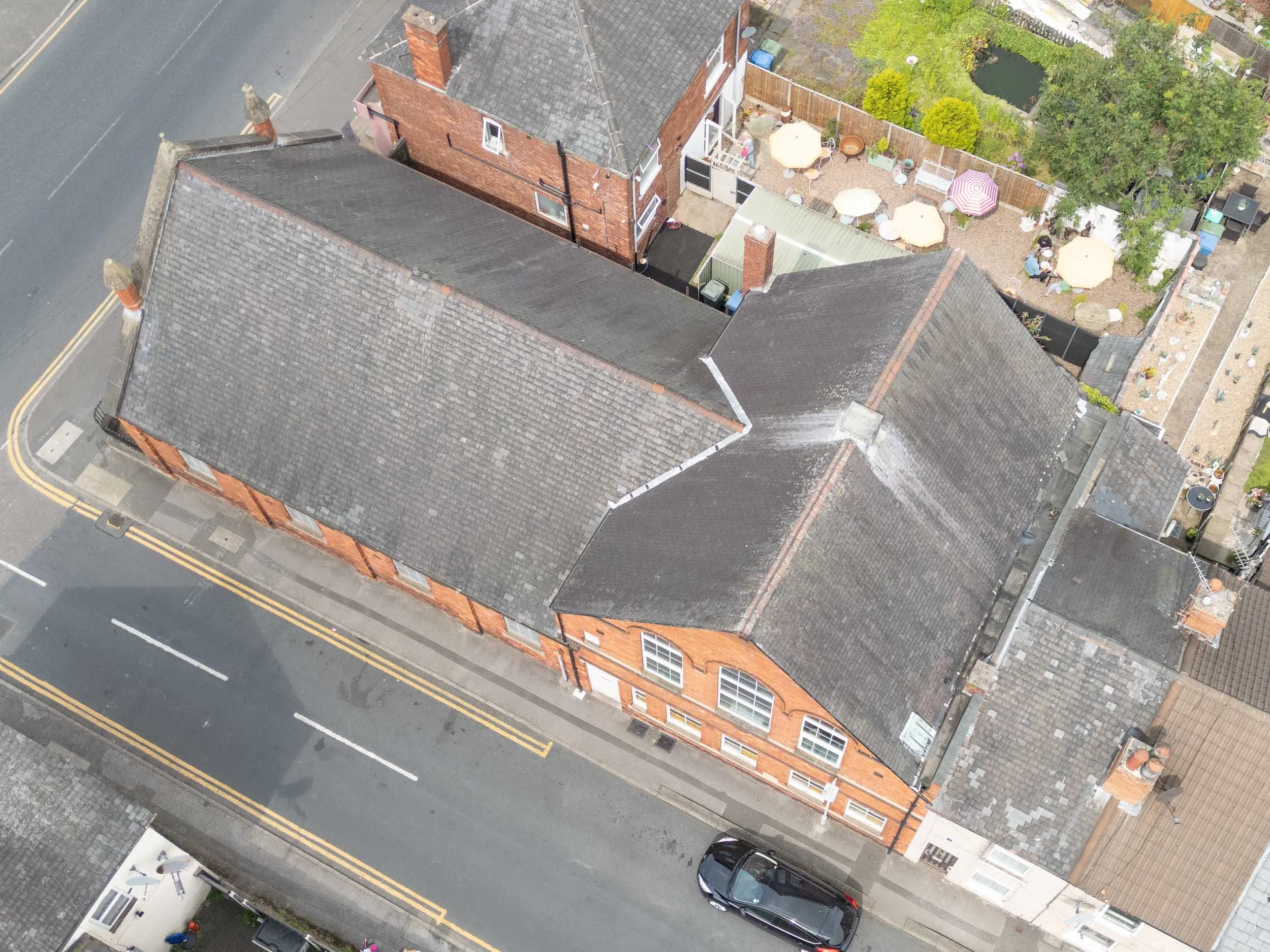
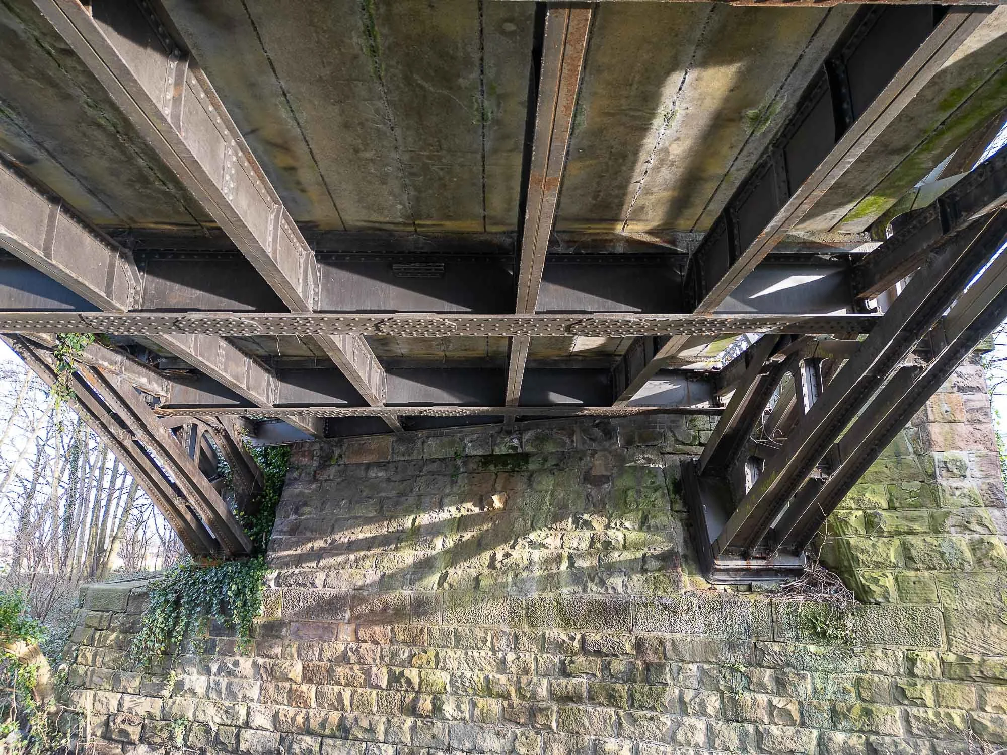
Property Inspection and Aerial Survey Drone Photography
Click on the image to enlarge and see the detail captured by drone photography.
Drones inspections fully assess commercial properties to identify potential issues
A top-down drone photo can show slipped tiles and other issues in difficult to reach areas
Drone images can detect cracks, dirt buildup, shading issues and physical damage on solar panels
Drone aerial surveys provide accurate, non-invasive assessments of wear, damage, or deterioration
Drone inspections get up close to give a better view of damage visible from from the ground
Get close-up visuals without the risks or costs of scaffolding or manual access
Mapping, Models, and More
In addition to visual property inspections and aerial surveys, we offer advanced drone mapping services, ideal for larger or more complex sites. These services include:
Orthomosaic mapping for planning and documentation
3D modelling for use in CAD and BIM systems
Photogrammetry for precise structural analysis
These outputs support everything from development planning and insurance claims to restoration projects and environmental monitoring. Take a look at our drone mapping services.
Book Your Drone Inspection or Survey Today
If you’re looking for a fast, safe, and affordable way to assess a building, structure, or site — our drone inspection and aerial survey services offer the perfect solution. No scaffolding. No disruption. Just clear, accurate data from above.
Contact our team today on 01332 890 592 for a FREE consultation and no-obligation quote.