Drone Mapping Services
Precision Drone Mapping for Smarter, Faster Decision-Making
At Drone Discovery Ltd, we provide cutting-edge drone mapping services designed to deliver precise, high-resolution geospatial data to businesses, developers, and land managers. Using Real-Time Kinematic (RTK) drones, Photogrammetry and Global Navigation Satellite System (GNSS) technology, we create accurate 2D orthomosaic maps and 3D models that support smarter planning, enhanced monitoring, and more efficient workflows across multiple sectors.
Our approach combines unmanned aerial vehicle (UAV) imaging with geospatial science, offering a faster, safer, and more cost-effective alternative to traditional ground-based surveying. Whether you’re managing a construction site, planning a development, or analysing environmental changes, our high-accuracy aerial mapping services provide the clarity and insight needed to make confident, data-driven decisions.
What Our Drone Mapping Services Offer
Our drone mapping services cover a broad range of sectors and needs:
Topographic & Site Surveys – Capture accurate elevation data and site contours for planning and engineering.
Construction Monitoring – Track progress, manage materials, and document changes with repeatable aerial data.
Stockpile & Volume Measurement – Calculate cut/fill volumes and manage resources with pinpoint accuracy.
Land & Forestry Management – Monitor terrain changes, tree counts, and landscape development over time.
These services are tailored to your project’s scale and delivered in professional, georeferenced formats ready for CAD, GIS, and BIM integration. Our mapping services are offered alongside other drone services for the construction industry.
How Does Drone Mapping Work?
Every drone mapping mission is planned meticulously. We configure flight paths based on your terrain and objectives, ensuring consistent overlap and resolution. Using RTK drones paired with GNSS mobile stations and ground control points (GCPs), we achieve centimetre-level accuracy—making our outputs suitable for engineering and regulatory compliance.
Our quadcopter drones are equipped with high-resolution cameras and the technology enables us to capture vast areas with resolution as high as 1cm per pixel. During a typical 45-minute flight, our drones capture hundreds to thousands of overlapping images that are processed into detailed maps and 3D models.The result is a consistent, high-fidelity representation of the surveyed environment, suitable for everything from design and development to conservation and marketing.
Accuracy levels are a central topic in conversations with our clients, particularly regarding whether you require relative (local) accuracy or absolute (global) accuracy:
Relative Accuracy: Accuracy Within the Map
Relative accuracy refers to how correctly features are positioned in relation to each other on the same map and within the mapped area. Even if the overall location is slightly off, the distances and relationships between mapped objects are preserved.
Example: If a bench is 5 metres from a path in real life, it will appear 5 metres away on the map as well.
Common use cases include:
Planning footpaths or parkland layouts
Inspecting rooftops for maintenance and asset management
Tracking changes in vegetation or drainage patterns
Producing promotional visuals for architecture or landscaping proposals
Absolute Accuracy: Accuracy with Geographic Coordinates
Absolute accuracy ensures that each point on the map corresponds precisely to real-world coordinates, such. This level of precision is vital when integrating drone data with official site plans, government records, or regulatory requirements.
Example: A boundary marker shown on the map matches its exact position based on GPS data.
Typically required for:
Submitting site plans for planning permission
Mapping utility lines or buried infrastructure
Flood risk analysis and coastal monitoring
Legal documentation for land transactions or development
Certified Mapping Flights with Accuracy and Assurance

Our mapping operations are conducted by CAA-certified drone pilots. We maintain full compliance with UK airspace regulations at all times giving you confidence that your geospatial data is both accurate and responsibly gathered.
Pre-flight surveys and flight permissions
Risk assessments
Public liability insurance through CoverDrone
Photogrammetry & 3D Modelling
Using photogrammetry, we process overlapping, georeferenced drone shots into highly detailed maps and models. By combining top-down and oblique (angled) aerial images, we create datasets suitable for a range of purposes.
2D Orthomosaic Map – Scaled, distortion-free imagery ideal for measuring distances, areas, and change over time.
3D Models – Accurate, realistic reconstructions of terrain, structures, and built environments.
Digital Twins – Virtual 3D models of assets for inspections, planning, and immersive visualisation.
High-Quality Deliverables
We deliver your data in formats that plug directly into your existing workflows. We’ll discuss your requirements before the job begins, All deliverables are securely shared via cloud storage, fully geo-referenced and quality-checked.
Orthomosaic Maps
Digital Surface & Digital Terrain Models
3D Models
Point Clouds
Mapping Services
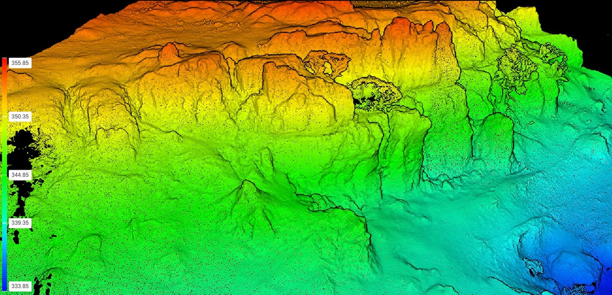
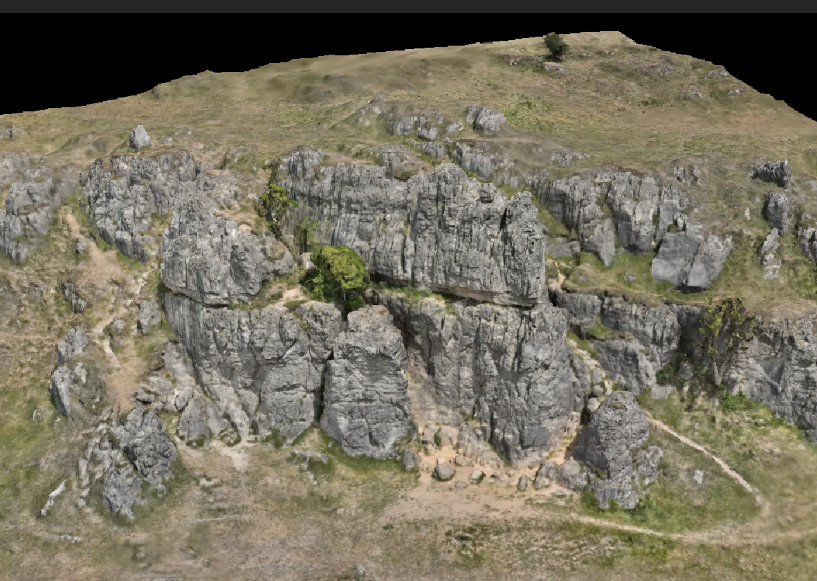
Examples of the outputs of drone mapping projects
A 3D mesh or model also known as a ‘digital twin’ is a digital representation of a real-world object or area
Read example case studies:
A point cloud shows numerous individual points, each with X, Y, and Z coordinates for precise measurements
A digital elevation model shows elevation points of structures or landscapes
Precision Mapping, Powered by Drones
From planning and design to inspection and visualisation, Drone Discovery Ltd delivers trusted, professional drone mapping services throughout the UK. Our certified pilots are ready to tailor a solution to your project, on time, on budget, and with industry-leading accuracy.
Contact us today on 01332 890 592 for a FREE consultation and no-obligation quote or visit our mapping portfolio to explore how drone footage can enhance your next project.