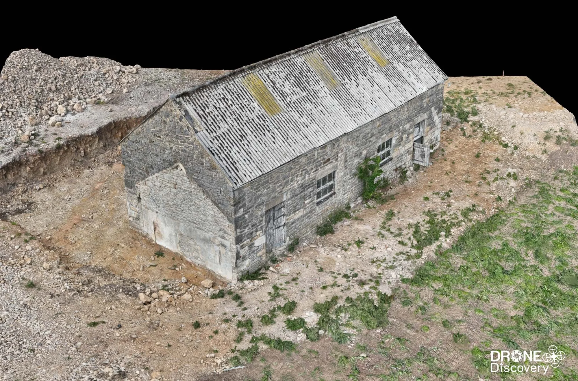
3D Model / Digital Twin
'Digital Twin' for Construction Planning
Overview
Prior to planning & development, our client required a digital twin to provide a highly detailed, virtual replica. This was to assist with planning and design and was also being used by the architects in charge of the development. As a result, a high level of accuracy was needed.
Sector - Construction
Output - 3D Model, 3D Point Cloud, Digital Elevation Model
Location - Derbyshire
Delivery - May 2025
Drone Data Capture Method
1. Office Preparation
Checked airspace restrictions and confirm required authorisations and permissions.
Completed pre-flight assessments in line with CAA requirements.
Planned the mission route, including flight altitude, speed, ground sampling distance (GSD) and area coverage using DJI Pilot 2.
2. Flight Route Planning:
Conducted an initial flight over the target area using oblique image capture.
Used DJI Pilot 2 software to create a rough point cloud or basic 3D model from the captured images.
Used the rough point cloud prcessed in the DJI RC Plus 2 controller to create and refine the specific survey area polygon. The Matrice 4 Enterprise has a 3D smart capture mode and the software then created the optimised spiral capture route for the drone to autonomously fly.
Settings such as GSD and speed were adjusted in order for the drone to capture the data precisely, with a low GSD and safely.
3. Data Capture Execution:
Flew the planned route using 5-directional oblique capture, where the gimbal captures images from multiple angles simultaneously.
Captured high-resolution images with the dedicated 4/3 CMOS 20MP sensor and mechanical shutter to reduce distortion.
4. Survey Quality Review:
After the flight, reviewed the quality report including photo points, RTK satellite fix status and image parameters.
5. Data Processing and Model Creation:
Imported the high-quality images into DJI Terra software.
Processed to generate a detailed 3D model (mesh, textured, accurate point cloud) and digital elevation model (DEM).
Utilised in-camera distortion correction and RTK capabilities to enhance model precision.
6. Reporting and Delivery:
Delivered the point cloud, 3D mesh & DEM to the client as well as uploading all data and pictures to Nira, providing the client an online resource to visualise and review.
Benefits
Enhanced Decision-Making
Data is accurately integrated into the model enabling better planning, risk assessment and problem-solving before construction begins.

Lifecycle Asset Management:
Beyond development, digital twins facilitate ongoing maintenance, predictive servicing and performance optimisation through continuous data updates.

Improved Collaboration
Digital twins provide a shared, highly detailed virtual environment accessible to all stakeholders (designers, contractors, clients), ensuring everyone works from the same up-to-date information.

Optimised Workflows
The ability to simulate construction sequences, detect clashes and forecast resource needs helps reduce inefficiencies, delays and costly rework.

Sustainability and Resilience
They support testing of sustainable design options and resilience against environmental factors, aiding compliance with regulations and sustainability goals.

Cost Reduction
Early identification of issues and more efficient resource management help lower overall project costs by avoiding mistakes and waste.