Manufacturer Survey
Roof Assessment Aerial Photography & Videography
Overview
Assess the very difficult to reach gulley’s in the factory roof plus a general assessment of all roofing areas across a large complex site
Sector - Manufacturing Plant
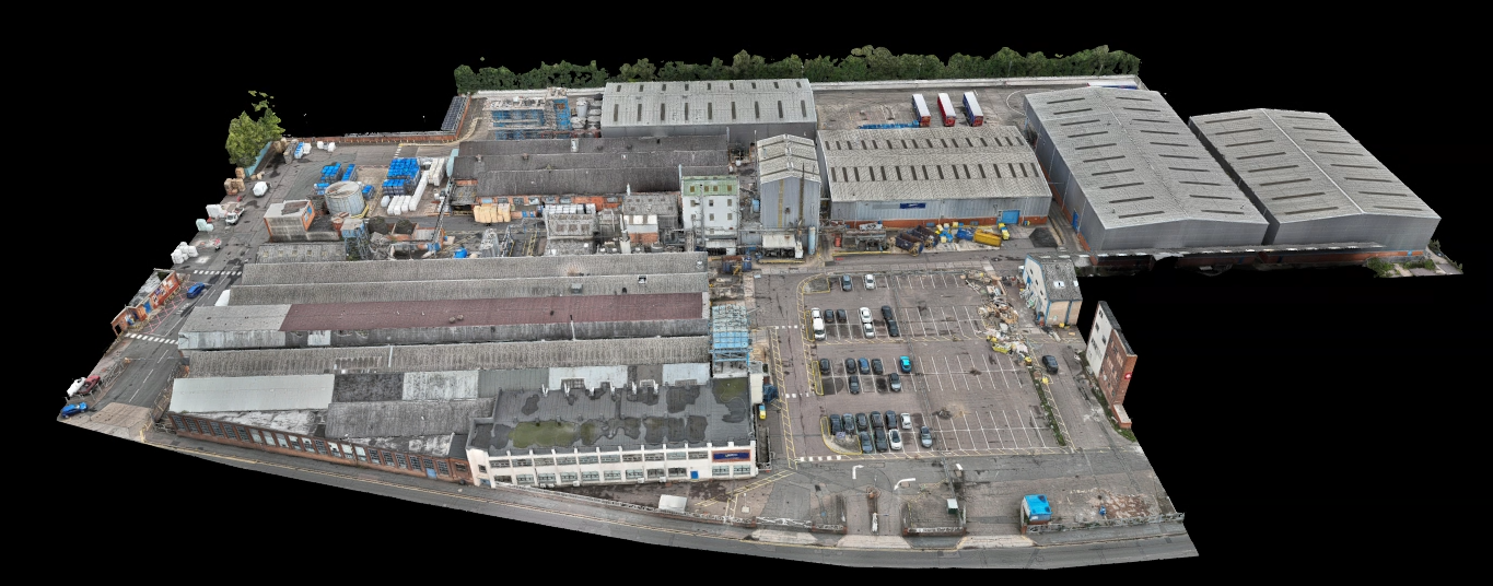
Output - Aerial photography, videography, 2D orthomosaic and 3D model
Location - Leicestershire
Delivery - Sept 2025
Drone Data Capture Method
1. Office Preparation
Checked airspace restrictions and confirmed required authorisations & permissions.
Completed pre-flight assessments in line with CAA requirements.
Planned the mission route, including flight altitude, speed, ground sampling distance (GSD) and area coverage using DJI Pilot 2
2. Pre-Flight Planning and Preparation:
Conducted an initial reconnaissance flight to verify site conditions, obstacles and lighting.
On site assessment: Reviewed factory roof plans and identified gullies and complex roof sections hard to access manually. Adjusted flight plan slightly to optimise flight angle and altitude, avoiding highest building point whilst maintaining lowest GSD safely possible, ensuring full coverage of gullies.
Ensured adequate photo overlap (80/80) to give high accuracy to the final deliverables.
Confirmed RTK GPS fix for centimetre-level accuracy.
3. Data Capture Mission:
Systematic Roof Survey: Executed the automated flight plan to collect overlapping images covering all roofing and gully areas.
4. Drone Configuration for Video & Additional Photography Footage:
Set Camera Angle: For gully inspections, tilted the gimbal camera to 45 degrees for oblique close-up footage, enabling a detailed view inside narrow channels.
Zoomed in to 7x optical zoom to capture the deep gully sections, whilst maintain a safe altitude above the roof during the flight.
Lowered the maximum horizontal speed to 3m/s to ensure the footage was captured in detail and with the zoom in mind.
Utilised omnidirectional sensors to safely navigate the difficult, congested roof areas.
Focused Inspection of Gullies: Hovered and circled at slower speeds to inspect and photograph tight gully zones from multiple angles for water pooling, debris and damage.
Real-Time Monitoring: Used live feed to adjust angles and focus on detected anomalies or hard-to-see locations.
5. Post-Flight Data Processing:
Uploaded and Processed Data: Transferred images to DJI Terra.
Created 3D Models and 2D Orthomosaics: Generated comprehensive visual maps and 3D models to gain an overall picture of the roof condition.
6. Reporting and Deliverables:
Imported the images into DJI Terra software.
Processed the imagery to generate a detailed 3D model (point cloud, mesh, textured model) and an accurate 2D orthomosaic map.
7. Reporting and Delivery:
Uploaded the model and orthomosaic to Nira and shared the link with client, alongwith the all files output to easily accessible formats.
Processed the video and additional photography from the drone and sent them over to the client for their inspection purposes.
Included metadata such as GPS coordinates, timestamps as well as accuracy report from DJI Terra.
Benefits
High-Resolution Data and Digital Records
Drones collect crisp, high-resolution photos and videos for defect analysis: leaks, cracked tiles, corrosion, build-up, structural wear and drainage issues are easier to spot and document.

Minimal Disruption to Business Operations
Drone surveys are non-intrusive, allowing factories to continue operating normally during inspections—without blocking access, affecting production or needing shutdowns.

Access to Inaccessible, Hazardous Areas
Drones can reach tight gullies, steep pitches and obstructed roof sections that cannot be safely or efficiently accessed via ladders, scaffolding, or lifts, without disrupting factory operations or risking injury.

Planning and Preventive Maintenance
Facility managers use the 3D model for precise planning of repairs, renovations, or upgrades, reducing errors and rework by extracting accurate measurements directly from the model.

Safety for Surveyors and Workers
Roof inspections are among the riskiest activities in facilities management. Using drones removes the need to send personnel onto high, fragile or hazardous roof areas, dramatically reducing risks of falls or injury.

Speed and Cost Savings
Drone surveys deliver fast, high-detail coverage of entire complexes in a fraction of the time required for traditional inspection teams; large surveys are completed quickly, allowing for rapid reporting and maintenance planning.